(This is an English translation of the original Japanese article.
The publication date refers to that of the Japanese version,
which differs from the upload date of the English version.)
A research group led by the National Fisheries University, Japan Fisheries Research and Education Agency, has developed a fishing support application called "Okisoko-kun," and put it into practical use. So far, it has been introduced to 20 offshore bottom trawl fishing vessels in Yamaguchi, Shimane, and Ehime prefectures. Normally, information such as catch amount is written on paper by fishermen on board the ship. However, by using this app to enter data on a tablet, catch information and the location of the fishing vessel are automatically stored in the cloud, which allows for real-time estimation of landing value of the fish catch, etc. The catch performance report, which is required to be reported to the supervisory agency, can also be prepared instantly, reducing the recording work of fishermen. These effects are expected to lead to visualization of fishing operation and enhancement of its efficiency.
Fishery support application "Okisoko-kun"
In 2021, the offshore bottom trawl fishery in the waters surrounding Japan caught 238,000 tons, making it a significant contributor to the nation's marine fishery catch, accounting for about 8%. One of the methods employed is the "Offshore trawl fisheries (two-vessel operation)," where a single fishing net is towed by two vessels operated side by side at a fixed distance. The primary catch includes sea bream, flounder, monkfish, and blackthroat seaperch (Figure 1).
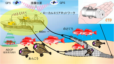
Figure 1: Operation image of two-vessel offshore trawl fisheries
(provided by the National Fisheries University)
Fisheries that employ such method must be operated with permission of the Minister of Agriculture, Forestry and Fisheries, and are obliged to report their daily catch status to the Ministry. Despite operations lasting as long as about a week, catch information (including fish species, catch amount, size) is still recorded and managed on paper. As the total catch amout is calculated by adding up these records manually, report preparation is time-consuming.
Therefore, the research group has developed an application called "Okisoko-kun," which allows users to record catch information on a tablet and save it on the cloud so that it can be shared among stakeholders.
First, for each operation, fishermen enter on a tablet the information of fish they catch, sort and cotain in boxes, such as fish species, their size and the number of boxes (Figure 2).
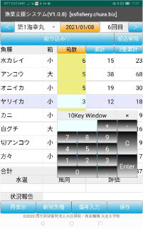
Figure 2: Entering fish catch data into Okikosoko-kun
(provided by Fisheries College)
Until now, each of the two fishing vessels recorded and calculated its catch information on paper and then combined the two of them. However, by connecting the two vessels with a local area network (LAN), the catch information entered on a tablet by each vessel is automatically summed up and the expected landing value is displayed in real-time (Figure 3).
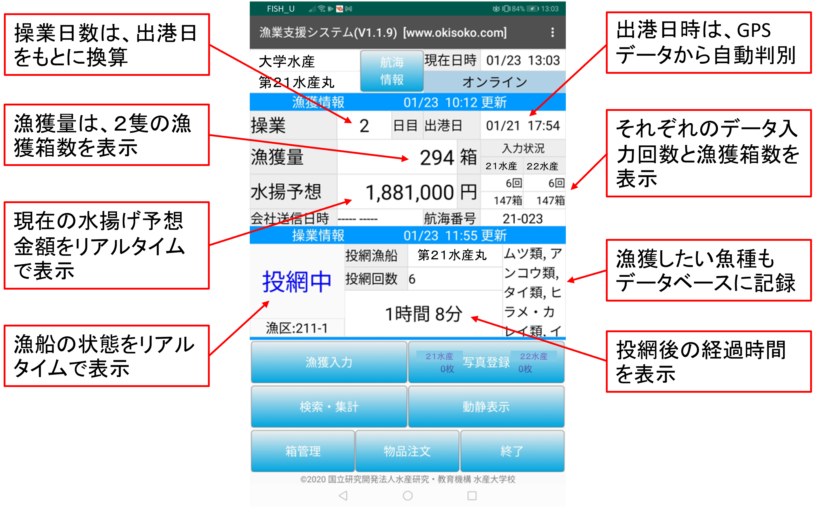
Figure 3: Okisoko-kun displays the estimated value of landing
(provided by Fisheries College)
By utilizing "Okisoko-kun," all the catch data, as well as the location information obtained automatically via GPS, can be stored on the cloud, enabling the preparation of catch performance reports with a single click. With the introduction of this application, the time required for fishermen to organize their data is reduced by approximately 20 minutes per operation. Given that one voyage (around one week) consists of about 50 operations, this equates to a reduction of roughly 17 hours per voyage.
Furthermore, "Okisoko-kun" records on the cloud, not only GPS location data (date and time, latitude, longitude, course, speed), but also the vessel's operating status during navigation such as net casting, and even the inventory of onboard consumables. This allows those managing the vessel from land (the fishing company) to monitor its status (current location and operating status) and efficiently deliver necessary consumables for navigation.
A fisherman using "Okisoko-kun" remarked, "it is easy for anyone to use, and enables real-time sharing of catch amount and expected landing value with crew members, increasing their motivation."
With the introduction of "Okisoko-kun", Shimonoseki fishing port records the highest landing value ever
Shimonoseki Fishing Port aims to develop its fishing industry as a growth sector by adopting a market-in approach utilizing "Okisoko-kun." Catch information collected from each vessel is aggregated in real-time and provided at the local market. Meanwhile, the demand for each fish species is evaluated on a five-point scale, and this feedback is provided to the fishing site with comments, facilitating two-way information sharing (Figure 4).
This has enabled the efficient landing of in-demand fish at the market, and in FY2001, the landing value per voyage reached an all-time high.
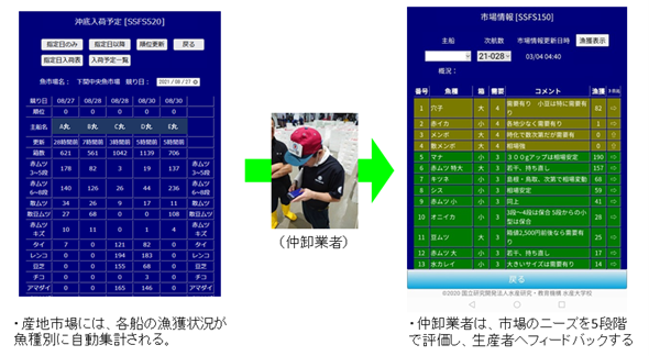
Figure 4: Two-way data linkage between fishing boats and intermediate wholesalers
(provided by Fisheries College)
Development of an AI that predicts the optimal fishing area in the future
The research group has also developed a high-precision fishery environment prediction model that forecasts the marine environment up to three days in advance. This is achieved by attaching a marine environment recording device (CTD*) to the fishing vessel's net to measure water temperature and salinity at various depths. Fishermen can access the automatically updated forecast information on the website and select their fishing grounds accordingly. Additionally, by analyzing past catch and marine data using AI, the group aims to develop an optimal operation area prediction system capable of determining "when, where, which fish can be caught and how much, and which sea area is better to operate in" before operation.
Hirofumi Matsumoto, associate professor at the National Fisheries University of the Japan Fisheries Research and Education Agency and representative of the research group, stated: "We aim to accelerate the digitization of the fisheries industry and contribute to regional revitalization."
Glossary
*CTD: CTD (Conductivity Temperature Depth Profiler), attached to the end of the fishing net, measures the bottom water temperature and salinity of the fishing ground. On the cloud server, CTD data (salinity, water temperature and depth) is linked with catch data (catch date and time, location, amount, fish species, etc.) collected by "Okisoko-kun". This allows not only "when, where and how much fish was caught" but also "what kind of environment (water temperature and salinity) the fish were living in" to be digitized.
Project name
Research Program on Development of Innovative Technology
(Fundamental Research Stage)
Project period
FY2019 to 2021
Title
Creation of Fundamental Technology for Optimal Operation and Automatic Collection of Catch Data using Artificial Intelligence
Leading research institutes
National Fisheries University,Japan Fisheries Research and Education Agency,
Kyushu University,
Showasuisan LLC,
Agriculture, Forestry and Fisheries Department, Yamaguchi Prefectural Government