In 2019, The National Agriculture and Food Research Organization (NARO) had developed an effective methodology to specify the dates when the respective paddy fields in a region were being flooded for puddling through utilizing the short-wave infrared band land monitoring images captured on cloud-free conditions by Sentinel-2 Earth observation satellites. The methodology uses the images to assess if each paddy field in the area was flooded on the day of the observation, and its accuracy rate was confirmed as 97 %. In 2020, the method was further improved to be able to use an additional resource from Sentinel-1 satellites with synthetic aperture radars that can capture land images even with cloud cover. These land monitoring images are provided free, and the method is expected to be used for the investigations to understand the actual usage of the agricultural water in an area and to adjust the existing water management plans to meet local demand.
Overview
Recent changes in paddy field agriculture have a direct influence on how the agricultural water is being used, resulting in the need in some areas to reconsider the existing water management plans. And while it is critical to understand the actual usage of the agricultural water in the area in order to make an appropriate adjustments to the plans, the conventional method of investigation to visit each sites requires too much time and effort when the area is large.
In 2019, NARO had developed a methodology to grasp the dates when the respective paddy fields were being flooded for puddling which is an important indicator to understand how the agricultural water in the area is being used, through utilizing the short-wave infrared band images by the Sentinel-2 twin satellites and released the operational manual. In the methodology, it analyzes the land monitoring images captured under cloud-free conditions by Sentinel-2 which revisit the same place every five days with two satellites (or average every three days depending on the locations) if the paddy fields were flooded or not on the day it was observed and goes further to specify the dates when the respective paddy fields in the area were being flooded.
The reliability of the outcome had been verified in our follow-up research in 2020 by comparing it to the visual observation of aerial photographs resulted in the accuracy rate of 97%.
In the same year, the methodology was improved to utilize also the images by Sentinel-1 satellites, which are equipped with the synthetic aperture radars capable of capturing images even with cloud cover. Although the accuracy rate of the outcome using the images by Sentinel-1 satellites was 79%, slightly lower rate than that of Sentinel-2, they have the advantage of capturing land images even with cloud cover. Even when there weren't enough images captured by Sentinel-2 because of the cloud cover and therefore specifying exact dates of paddy fields being flooded is difficult, by using Sentinel-1 data supplementary in the method, the dates will become more precise, may it be less accurate.
This method utilizes the Sentinel data provided free by European Space Agency and can be utilized by the officials to carry out the surveys to understand the actual use of the agricultural water and to review and improve the existing agricultural water management plans.
For Inquiries
Contact: http://www.naro.affrc.go.jp/english/inquiry/index.html
Reference Information
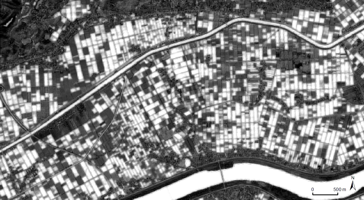
Fig.1 Modified Normalized Difference Water Index data captured by Sentinel-2 satellite on April 20, 2018
(Inashiki City, Ibaraki Prefecture)
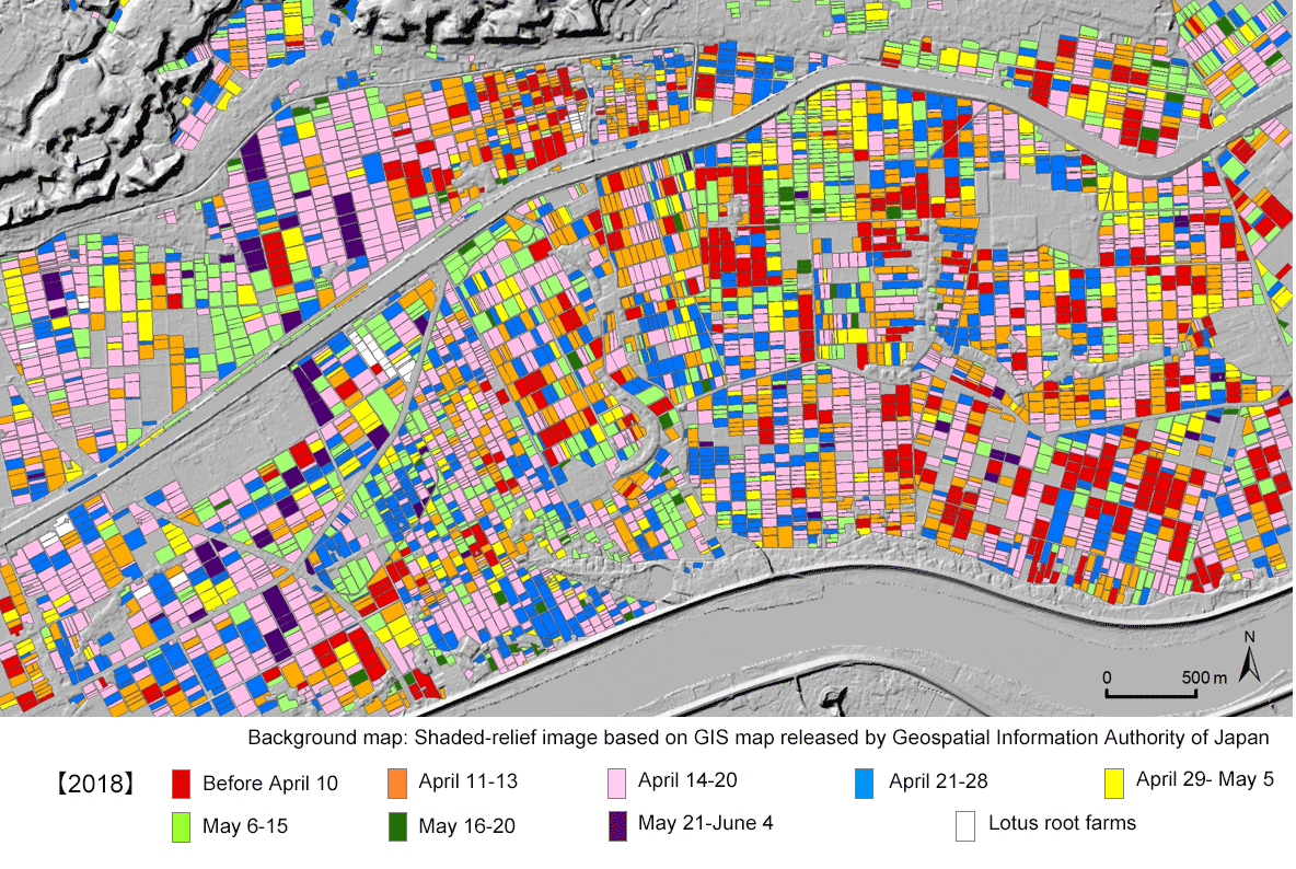
Fig.2 The map showing the dates when the paddy fields were being flooded in 2018, utilizing eight Sentinel-2 sattelite images
(Inashiki City, Ibaraki Prefecture)
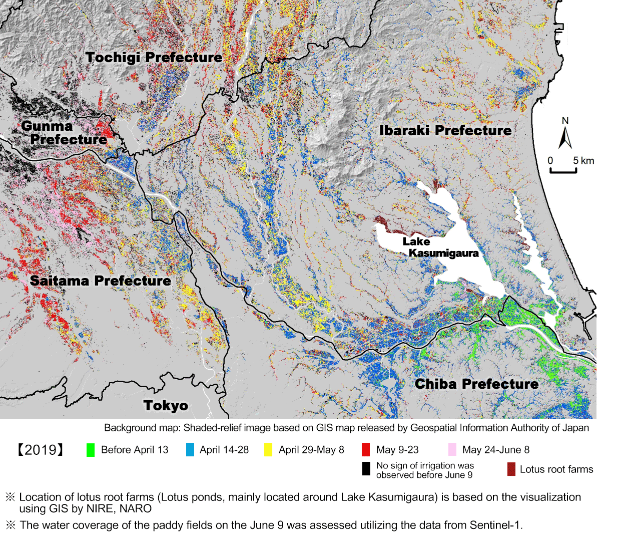
Fig.3 The map showing the dates when the paddy fields were being flooded in 2019, utilizing four Sentinel-2 images and a Sentinel-1 image
(Tone bashin and the surrounding area, Kanto)