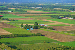
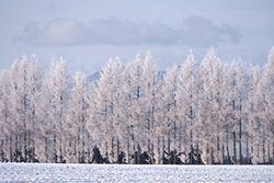
Memuro Town is located in the east of Hidaka Mountains and in the middle west of Tokachi Plain, with about 42% of the land being agricultural land and about 40% is forested. This town boasts one of the highest rate of clear weather days, with average annual temperature of 6 degrees centigrade. Summer temperature exceeds 30 degrees centigrade, while the winter temperature drops below -20 degrees centigrade, showing a wide range of temperature. Being blessed with the fertile ground and the advantageous climate conditions, the farmers operate large-scale agriculture mainly for upland farming and holds the largest crop area and the highest yield of wheat, potatoes, adzuki beans, sugar beet, and corn etc., in Hokkaido.
Memuro Town : Living Information
| Name | Category | Map | Notes |
|---|---|---|---|
| Memuro Town Hall | Administrative facilities | map |
Approx. 7 min. from Research Division by car |
| Memuro Station | Railway station | map |
Approx. 7 min. from Research Division by car |
| Memuro Public Hospital | Hospital | map |
Approx. 6 min. from Research Division by car |
| Obihiro City Hall | Administrative facilities | map |
Approx. 25 min. from Research Division by car |
| Tokachi Obihiro Airport | map |
Approx. 30 min. from Research Division by car |
|
| Convenience Store | Daily necessities | map | |
| Supermarket | Food items | map | |
| Hardware store | Daily necessities | map | |
| Electronics retail store | Electric appliances | map | |
| Restaurant | Japanese | map | |
| Western | map | ||
| Chinese | map | ||
| Noodles | map | ||
| Fast food | map | ||
| Ethnic food | map | ||
| Hospital | General hospital | map | Need a reservation generally |
| Clinic | map | ||
| Dentistry | map | Need a reservation generally | |
| Post office | map | ||
| Bank | map | ||
| Accomodation | map | ||
| Christian church | map | ||
| Temple | map |